Laser Survey vs LiDAR: Which Mapping Method Suits Your Project?

Technology has advanced way more in all the aspects. Gone are the days of manual surveying and interventions which were quite prone to the errors as well as consumed a heck of time. With digitization, many surveying techniques are approaching in the market. Selecting the right surveying technology is crucial in the era of digital construction and precision mapping. Among the most widely adopted techniques today are the Laser Surveys and the LiDAR (Light Detection and Ranging). While both serve the purpose of collecting the spatial data with high accuracy, their differences lie in their technology, application scope and even the deliverables.
Not sure which to go with? Let’s break it down together.
Understanding the Basics
Laser Survey
Laser surveys typically involves the terrestrial laser scanning (TLS) or total stations. These instruments use a laser beam to measure the distances from the instrument to a surface, capturing the accurate spatial coordinates of the specific points.
- Output: 2D/3D coordinates, cross-sections and the elevation data.
- Common Use Cases: Building layouts, infrastructure measurement, deformation analysis.
LiDAR
LiDAR is an advanced remote sensing method that sends thousands of laser pulses per second and measures their return time to generate a detailed 3D point cloud of the surveyed area. It can be mounted on the airborne (drone, helicopter) or terrestrial platforms.
- Output: Dense 3D point clouds, digital terrain models (DTM), digital surface models (DSM) and intensity maps.
- Common Use Cases: Topographic mapping, forest surveys, corridor mapping, flood modeling and large-scale infrastructural projects.
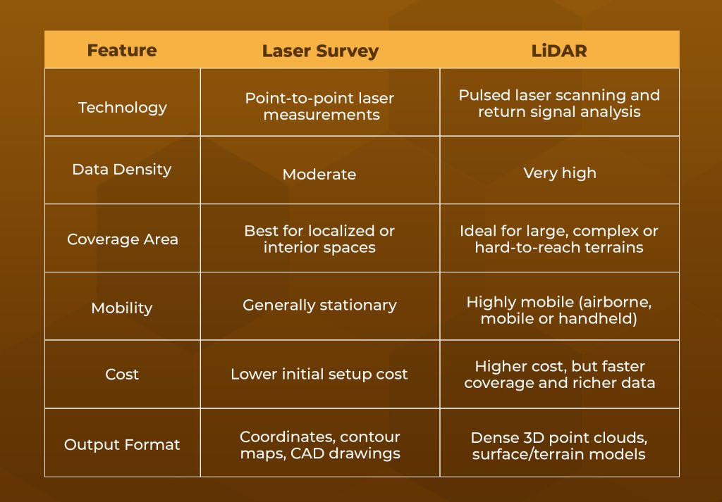
Key Differences: Laser Survey vs LiDAR

Which One Should You Choose?
Choose Laser Survey If:
- You need precision in a confined or indoor environment (e.g., structural assessments, floor plans).
- The project area is small or easily accessible.
- Cost is a key consideration and high-density point clouds are not essential.
Choose LiDAR If:
- The site is vast, uneven or inaccessible (e.g., forests, roadways, cliffs).
- You need dense, 3D spatial data for modeling or simulations.
- Time is a critical factor and speed of data acquisition is essential.
Where Point Cloud to BIM Services Fit In
Regardless of whether you use a Laser Survey or LiDAR, the result is typically a point cloud—a detailed 3D representation of real-world conditions. That’s where Point Cloud to BIM Services play a critical role. These services converts the point cloud data into accurate 3D models using the platforms like Revit and enabling the teams to plan, visualize as well as coordinate effectively.
Especially in the renovation or retrofit projects, the Point Cloud to BIM Services helps to bridge the gap between the existing site conditions and new design workflows hence reducing the errors and improving the project timelines.
Combining Laser Survey & LiDAR: A Hybrid Approach
For complex projects especially in the infrastructural or historic building restoration, combining both methods delivers the best of both the worlds. Laser Surveys can provide millimeter-level detail in the interiors while LiDAR captures the broader terrain or exterior structures.
At QeBIM, we offer top-notch BIM Services and Point Cloud to BIM Services, leveraging data from the Laser Surveys and LiDAR to create a clash-free, high-precision models. Whether it’s a small-scale home upgrade or a large infrastructure venture, our experts help tailor the right survey method to your project scope and goals.
Conclusion
The decision between the Laser Survey and LiDAR isn’t about which is superior — it’s about which is right for your project. Each technology has its strengths and understanding them helps you to make smarter, more cost-effective and technically sound choices for your surveying needs.
If you’re unsure which method suits your next project, connect with our expert for a free consultation. Let’s make your survey smarter, faster and more accurate.